Sep 10 2013
The Centre for Carbon Measurement at the National Physical Laboratory (NPL) is working to improve ocean colour measurements vital for modelling climate and monitoring the health of the oceans. Colour differences (change in spectral reflectance of sunlight) in the oceans can provide a measure of phytoplankton and algae blooms - important as their chlorophyll serves as a natural sink of CO2 and also sometimes pollution.
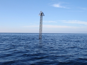
 Ocean colour measurements are made at the BOUSSOLE buoy off the coast of France
Satellites constantly monitor the surface of the Earth, collecting data that is fed into climate models to underpin our understanding of issues like climate change. Ocean colour is one of many measurements made by these satellites, and one of the most challenging. The oceans absorb much more light than the continents, so the satellite measurements need to be sensitive enough to detect small changes in whatever little light is reflected back to them from the water.
The instruments on board satellites that measure ocean colour are called 'radiometers'. These are calibrated before the satellite is launched, but also checked regularly against measurements made at sea. This post-launch calibration process is vital to ensuring the data collected by the satellites is accurate. However, the radiometers used to take measurements of ocean colour at sea currently have uncertainties of around 5%, of which the absolute radiometric calibration uncertainty (traceability) is higher than 2%. NPL has been working with international experts as collaborators to improve this figure.
The European Metrology Research Programme (EMRP) funded part of this work through the project 'Metrology for Earth Observation and Climate' (MetEOC), which aims to improve a wide range of measurements related to the remote monitoring of the Earth. The EMRP is implemented by EURAMET, organised by 23 National Measurement Institutes and supported by the European Union. Experiments were carried out in the darkroom facilities at NPL to investigate the sources of uncertainty when making ocean colour measurements and to improve the calibration of commercial radiometers. The tests found that, by using a primary irradiance lamp, such as those maintained by NPL, rather than a secondary standard, and modifying the calibration procedure by aligning each 'colour' channel of the radiometer in turn, the absolute radiometric calibration uncertainties could be reduced to around 1%.
NPL scientists have also been involved in the calibration and characterisation of 13 radiometers that are currently operating at a measurement site in the Mediterranean Sea, around 60 kilometres from Nice in the south of France. Here, a buoy, specially designed for the task of acquiring radiometric quantities, is permanently moored as part of a project called BOUSSOLE. It is from this buoy that ocean colour measurements are made to check the data obtained by European (and international) satellites. Essentially, the readings from the satellite instruments are compared to those from the buoy when the satellite passes overhead.
This work was carried out for the European Space Agency (ESA), one of the supporters and funders of the BOUSSOLE project, in collaboration with the core French scientific team from the Laboratoire d'Océanographie de Villefranche (LOV) and the Centre National d'Etudes Spatiales (CNES). The aim was to improve the demonstration of traceability of the ocean colour measurements made at the buoy as part of ongoing efforts under the international framework Quality Assurance Framework for Earth Observation (QA4EO).
In the longer term, it is hoped that high accuracy traceable measurements direct from space through specially-designed satellites like the NPL TRUTHS mission would be able to update the calibration coefficients of instruments on a reference test site like BOUSSOLE on a regular basis and improve the accuracy further - since these would not only provide radiometric calibration of the surface instruments but also account for the intervening atmosphere.
Monitoring the Earth from space is the only feasible method of gathering data across the whole of the planet, but satellites also need support from a wide range of ground-based, or in this case sea-based, measurements. By improving the measurements made at sea, NPL will ultimately help improve the reliability of measurements made in space. This will build our understanding of the Earth's climate system and confidence in the models that aid policy makers in their response to climate change.
Source: http://www.npl.co.uk