Oct 20 2008
Using space-based technology developed during ESA’s gravity mission studies, a novel gradiometer is being developed by a UK-based company to help oil and gas companies find the most appropriate locations to drill wells and plan further exploration.
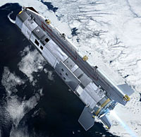 Over its lifetime of about 20 months, GOCE will map global variations in the gravity field with extreme detail and provide a unique model of the geoid, which is crucial for understanding ocean circulation, sea-level change and ice dynamics – all of which are affected by climate change. Credits: ESA - AOES Medialab
The gravity gradiometer measures the variations in the Earth’s gravity, or in technical terms, the ‘differential acceleration’. These variations help to measure the density of the subsurface, therefore providing information on the Earth’s geology. From data acquired through the gradiometer, an image of the subsurface geology can be derived. This image provides information which can help oil and gas companies looking to drill wells or plan further exploration.
The technology behind the gravity gradiometer was originally developed as one of two potential candidates to measure gravity on ESA’s Gravity-field and steady state Ocean Circulation Explorer (GOCE) mission, planned to be launched this year.
Funded under ESA contract, the basic technology development for the superconductive gravity gradiometer was initiated in 1993, with the scope to develop a European spaceborne superconducting gravity gradiometer. Eventually ESA selected the other candidate, an Electrostatic Gravity Gradiometer, for its GOCE mission, as the superconducting technology was judged not to be ready for spaceborne implementation. Nevertheless for airborne terrestrial implementation it had potential.
The space-derived superconducting gravity gradiometer technology was further developed by British geophysical imaging company ARKeX for use in the oil and gas industry. This technology transfer was supported from the beginning by Nathan Hill, Qi3 Managing Director. Qi3 is Technology Broker in ESA’s Technology Transfer Programme network of technology brokers throughout Europe.
The ARKeX gravity gradiometer offers other major advantages for the oil and gas industry. Seismic surveys are presently the prevalent method used to find new gas or oil deposits and often use dynamite to produce sound waves. In contrast, gravity gradiometry is a non-invasive technology which can be used in environmentally sensitive areas without causing immediate disruption.
The instrument is mounted on a light aircraft and a survey grid is flown over an area to record the different signals from the ground below. As a large area can be covered quickly from the air, the cost of performing a survey is 10 times cheaper than performing a traditional seismic survey.