AZoCleantech speaks with Professor Carlton Pennypacker, a physicist in the Department of Physics and Space Sciences Lab at the University of California, Berkeley. The following interview discusses the impact of wildfires, how climate change is driving these wildfires, and the future of wildfire detection and monitoring.
Can you explain why the battle against wildfires is so important?
Wildfires are an imminent threat to our planet in many ways. For example, there are many billions of dollars lost every year in California. Estimates suggest that hundreds of billions of dollars have been lost over the last few years in terms of property. More importantly, lives, probably one hundred lives per year minimum, are lost due to wildfires. That number is only going to go up and get worse because of climate change.
In addition, the entire San Francisco bay area was previously shut down for a week or two because of smoke, and we might be facing that again with the existing fire. With these wildfires, people can’t breathe and all sorts of lung problems arise.
There are those immediate aspects, but a longer-term and very worrisome element is carbon dioxide production due to wildfires. I estimate that between 8 and 12% of California’s CO2 emissions result from wildfires these days.
Currently, in California, there is the Dixie fire, the fourth biggest fire ever in California. Our fire service is fabulous. They risk their lives, and they’re very good at putting them out, but when these mega-fires come, they are spread across hundreds of thousands of acres. It’s very tough on everybody, and unfortunately, we’re seeing more of those.
What role is climate change playing in driving wildfires?
Climate change is at the core. The fuels for the fire are dryer; humidity at nighttime is lower. Previously, fires used to set down at night, and they wouldn’t burn nearly as much. But now they’re continuing because it’s so dry at night - that’s another climate change effect.
The winds are tougher. It appeared for a while that winds were decreasing on planet earth. Now they’re picking up again, and as a result, they are making fires worse. In addition, there’s so much intensity in the fire that they create their own winds – firenadoes can be seen – these are tornadoes around the fire. In addition, there’s so much energy in the fires, they can send an ember miles away, and that can potentially start a fire a mile away, then that fire will merge with the existing fire. So the apparent spread rate could be 10 miles an hour and 20 miles an hour.
When we started our work about seven or eight years ago, we looked at the predictions from climate scientists, and every few years, it was going to get worse and worse. We’d see from the research that we were going to see more fires in Northern California and that’s where the big fires have been, for example, in Paradise, the Dixie fire, because it’s getting drier and drier in that area. We didn’t use to have fires that size in Northern California. Those fires used to be confined to places such as LA and San Diego in Southern California.
How can data from infrared sensors be used to create models of fire behavior?
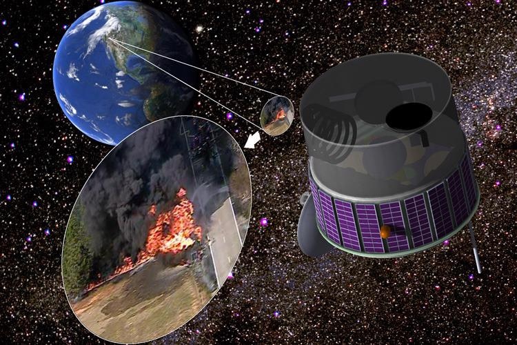
The satellite we’re trying to build right now will have a geosynchronous orbit. It will be a good bell-ringer in terms of fire behavior. We then want to develop lower earth orbit and mapping systems in airplanes to understand what is going on with the fire. This could help indicate the temperatures of wildfires, how fast they are spreading, and how the spread rate relates to fuel. Infrared detectors are so sensitive and effective now, they have progressed tremendously. Seeing embers from 20,000 feet is possible now.
We have onboard computing to make sure we know exactly where on the ground things are. The data that we have includes infrared measurements at several wavelengths. Previously, we’ve never had that data easily available to go into the models. Those making models are hampered by not having good data to correct their models with or test the models against. I think that we will see a gradual improvement in the models as we can provide them with more information.
What advantages does the modeling of wildfires present to firefighters and emergency responders?
Coupled with high-frequency imaging, if you know exactly where the perimeter is, how sensitive, and in particular, you know where the fuel is, you know the direction of the wind, and the altitude, you can have a pretty simple model - it can tell you where the fire’s going to go.
You want to put resources where the fire is going to do the most damage. And if you can predict where this is going to be, where it’s going to grow and hurt people, property, and natural resources, then you put all the resources you can in that area.
And there are resources at all altitudes. For example, very large air tankers have been a big help with fires. These are converted DC10s and 747 jumbo jets. They are filled with 30,000 gallons of water or fire retardant, and they can lay down a fraction of a mile strip of retardant. That’s a big help, and works at a scale we haven’t been able to see until now.
Can you explain some of the early influences on this current system?
The biggest influencer is the needs of society and our planet. The climate crisis is just getting worse and will keep getting worse until we truly reverse climate change. There’s no way out of this except bringing the CO2 down.
I’m grateful that I am based in a supportive university research environment. We have good support from laboratory directors and other staff. In addition, I spent a lot of my career detecting supernovas in galaxies up to a billion light-years away. A lot of that technology has been an influence, including being able to find small signals.
Within five years, I hope we’ll be saving many lives and helping our planet a lot. I believe fate has allowed me and my colleagues to use our skills in a very proactive, helpful way for the planet.
This new system is a streamlined version of FUEGO. Can you explain the technological advances that have occurred since then that have allowed for the new system?
Seven years ago, we came up with an idea for a satellite, and working with the grant from The Moore Foundation, we’ve been able to make it smaller, cheaper, and better. The satellite used to have a bigger mirror, and we realized we don’t need such a big mirror. This system can be a parasitic payload on an existing satellite bus.
A lot of technological software has tilted in our favor. Computation and everything only gets better year after year, as well as imaging. So all those things have kept pushing us forward. Also, there is more awareness now, people love space now in a way they didn’t before, and it’s become much more accessible. There are more launches to geosynchronous and lower earth orbit. We hope eventually to build a fleet of lower earth orbit satellites for easy mapping instead of having to send an airplane out. That’ll be exciting.
How did the Gordon and Betty Moore Foundation grant come about, and how will this money be used?
We have a preliminary design of the satellite. We have optics, identified detectors, and thinking about what kind of a satellite to base it on. We’ve made a lot of progress, and that was all done by The Moore Foundation. The grant came about because The Moore foundation was in the Bay Area and suffered under these terrible smoke clouds that shut down life. The Moore Foundation cares about the quality of life in California, in general. When we started progressive ideas about how to stop fires early, they became very sympathetic.
When do you expect the system to be rolled out?
Some parts of it are working already. With the ground-based system, we’re analyzing millions of images a day looking for smoke. We’re trying to use some military satellites in a way that won’t reveal features of the satellites, protect the satellites, but they can help out in our detections. We have a pilot system underway already. Hopefully, if we acquire funding for the next stage, I expect the launch to be in around three to four years.
What future improvements do you anticipate will be made in terms of wildfire detection?
The software will keep improving. Having a high-speed data rate of fire images, images coming down every second or so, has never been done. I think that will open up a huge amount of software that we don’t even know about yet, in terms of finding fires and measuring them. I expect those improvements to occur over the next few years. It is going to be an exciting time.
The ultimate aim is for the system to be adapted to collect observations from geostationary satellites. What advantages does such positioning have over an airborne system?
We can capture an image of the whole Western United States in one image. An airplane would have to be going at 100,000 miles per hour to capture that image, whereas we cover it instantaneously. Airplanes are great for mapping a fire once you know where the fire is, but for finding the initial outbreak, you want a wide field, 24/7 system like we’re proposing.
How will the data from airborne observations be used to help refine the system for this application?
I view our first system as a pathfinder type of pilot, but the airborne system will have many spectral bands. With that data, we’ll watch the fires evolve. For example, we will determine exactly which infrared colors are best and which infrared wavelengths are best to use.
Where can our readers find more information?
Your readers can find more information on our website.
About Professor Carlton Pennypacker
Carlton R. Pennypacker is an astrophysicist at the University of California, Berkeley and the Lawrence Berkeley Laboratory and is the principal investigator for the Hands-On Universe project.
Dr. Pennypacker has been motivated by the power and potential of student and scientist partnerships when teachers and students started discovering supernovae in the Hands-On Universe project.
He was awarded the Prix Jules Janssen of the French Astronomical Society in 2010.
Dr. Pennypacker has spent much of his career as a research astrophysicist, receiving his Ph.D. from Harvard in 1978. His principal research was the studying of supernovae and the building of techniques for their automated discovery.
With Rich Muller, he co-founded the Berkeley Supernova Search, which later became the Supernova Cosmology Project. He shared the 2007 Gruber Prize in Cosmology and the 2015 Breakthrough Prize in Fundamental Physics for the Supernova Cosmology Project's discovery that the expansion of the universe is accelerating.
Interview questions provided by Robert Lea.
Disclaimer: The views expressed here are those of the interviewee and do not necessarily represent the views of AZoM.com Limited (T/A) AZoNetwork, the owner and operator of this website. This disclaimer forms part of the Terms and Conditions of use of this website.