As the human population increases, so does the amount of waste generated. At present, plastic can be discovered in every environment on Earth. Riparian environments could be hotspots for pollution, as rivers tend to gather and transport waste along their course.
In rivers, plastic waste has the ability to increase flood risks, decrease water quality, and harm plant and animal species that utilize the river and encircling habitats.
 Ayouttemperature. Image Credit: University of Tsukuba.
A first step in solving the litter issue is comprehending where plastic accumulates.
Many techniques have been tested to map litter in different environments but these are often complex or expensive. We set out to find a simpler, cost-effective means of mapping pollution in riparian systems that can be broadly applied.
Fatwa Ramdani, Study Lead Author and Professor, University of Tsukuba
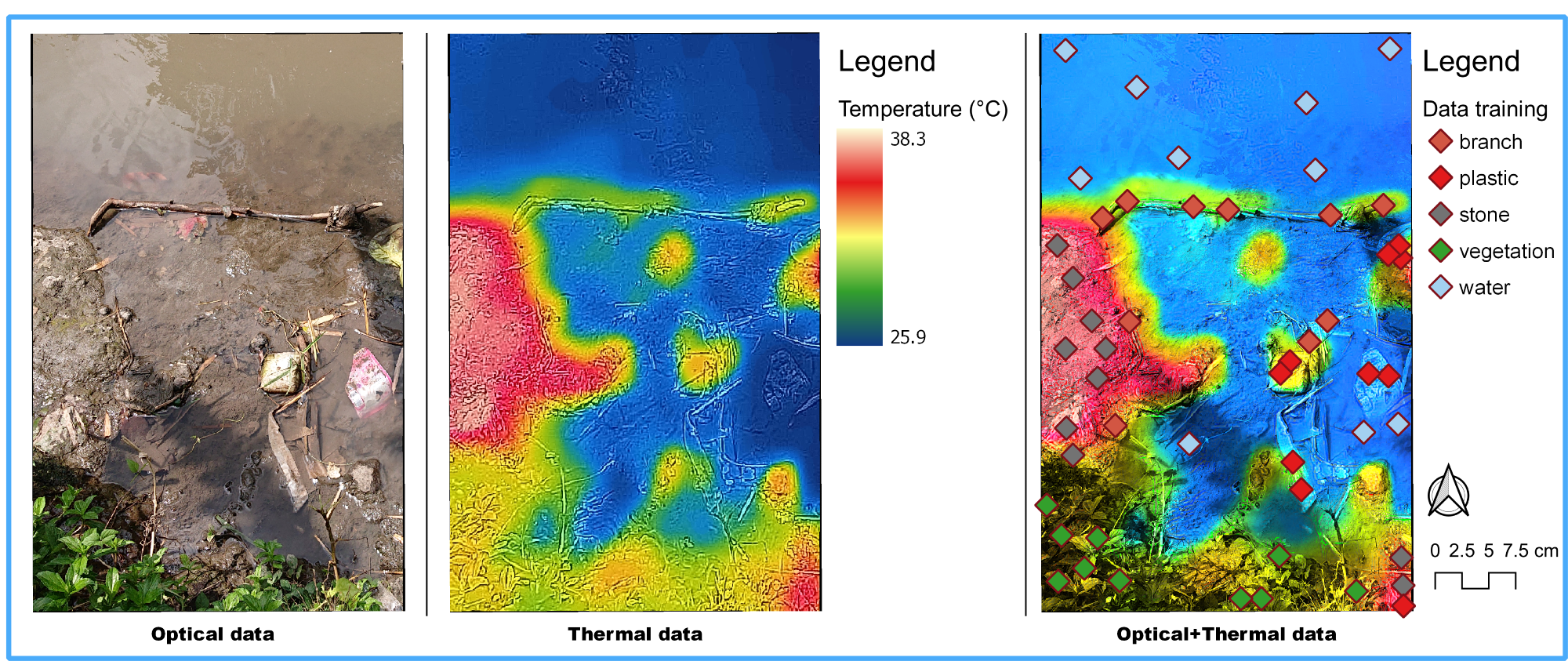
To perform this, the scientists utilized a combination of very high-resolution optical and thermal images, gathered with the help of low-flying drones. The drones were utilized to detect plastic pollution along the Brantas River, Malang City, Indonesia.
Furthermore, a machine learning method was utilized to process the images. Three different machine learning classifiers were tested to note which could most precisely identify various types of objects, such as plastics.
Using these methods, we found that a combination of optical and thermal images produced the most accurate estimates of the amounts of plastic litter. On their own, neither image type produced particularly accurate results.
Fatwa Ramdani, Study Lead Author and Professor, University of Tsukuba
The scientists discovered that one classification technique—XGBoost—functioned better compared to the others tested. However, a few challenges still exist with this technique. For instance, plastic floating on the surface or immersed in the water impacted the results to a certain extent.
This novel technique is a beneficial step toward determining pollution hotspots. Comprehending where plastics are accumulated in the environment can help target clean-up measures and might offer insights into the sources of pollution.
Journal Reference
Ramdani, F., et al. (2022) Mapping riparian zone macro litter abundance using combination of optical and thermal sensor. Scientific Reports. doi.org/10.1038/s41598-022-09974-4.