May 28 2019
The ROSETTA-Ice project, a multi-institutional data collection survey of Antarctic ice carried out for three years, has put together an unparalleled view of the Ross Ice Shelf, its structure, and how it has been transforming over time. In a research published recently in Nature Geoscience, the ROSETTA-Ice team members describe how they discovered an ancient geologic structure that limits where ocean water flows. The discovery indicates that local ocean currents may play a paramount role in the future retreat of the ice shelf.
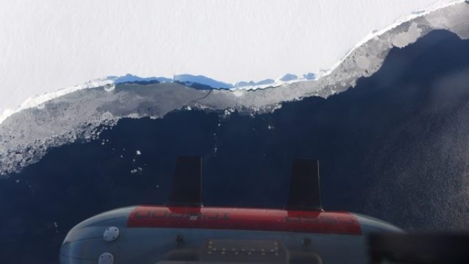 The IcePod flying over the Ross Ice Shelf in Antarctica as part of the ROSETTA-Ice project. The pod is lowered from an LC130 aircraft and holds a series of instruments that are critical to completing this project. (Photo credit: Winnie Chu)
Ice shelves are huge expanses of floating ice that hold up the flow of Antarctic ice into the ocean. ROSETTA-Ice gathered data from the enormous Ross Ice Shelf, which helps decelerate the flow of around 20% of Antarctica’s grounded ice into the ocean — equal to 38 feet of global sea level rise. Antarctica’s ice is already melting at a very fast rate. Forecasting how the ice shelf will transform as the planet continues to warm needs insight into the complex ways in which the ocean, ice, atmosphere, and geology interrelate with each other.
To get a proper insight into these processes, the multidisciplinary ROSETTA-Ice team scrutinized the Ross Ice Shelf quite like explorers traveling through a new planet for the first time. The team faced a core challenge of how to collect data from an area the size of Spain, and where ice that is often over a thousand feet thick prevents more traditional ship-based surveys of the seabed. The solution was IcePod, a first-of-its-kind system built to gather high-resolution data from all over the Polar regions. The IcePod was created at Columbia University’s Lamont-Doherty Earth Observatory and placed on a cargo plane. Its instruments measure ice shelf thickness, height, and internal structure, and the magnetic and gravity signal of the rock below.
Every time the team flew over the ice shelf, the IcePod’s magnetometer (which computes Earth’s magnetic field) displayed a flat and virtually unchanging signal. That is, until midway across the ice shelf, when the instrument became activated, showing large variations, quite like the heartbeat on a cardiogram. When the team plotted their results, it became evident that this “heartbeat” always showed up in the middle of the ice shelf, detecting a formerly unmapped segment of the geologic boundary between West and East Antarctica.
The team then applied IcePod’s measurements of Earth’s gravity field to model the shape of the sea floor under the ice shelf. “We could see that the geological boundary was making the seafloor on the East Antarctic side much deeper than the West, and that affects the way the ocean water circulates under the ice shelf,” explained Kirsty Tinto, the Lamont research scientist who guided all three field expeditions and is the study’s lead author.
The researchers were able to run a model of ocean circulation and its impact on ice shelf melting using the new map of the seabed under the ice shelf. In contrast to the Amundsen Sea to the east, where warm water crosses the continental shelf to cause fast melting of the ice shelves, little warm water flows into the Ross Ice Shelf. In the Ross Sea, heat from the deep ocean is eliminated by the cold winter atmosphere in a region of open water, referred to as the Ross Shelf Polynya, before flowing beneath the ice shelf. The model revealed that this cold water melts deeper portions of east Antarctic glaciers, but it is stayed away from the west Antarctic side due to the depth change at the ancient tectonic boundary.
In an astonishment twist, however, the team learned that the polynya also adds to a region of strong summertime melting along the ice shelf’s leading edge. This melting was verified in the radar images of the ice shelf’s internal structure.
We found that the ice loss from the Ross Ice Shelf and flow of the adjoining grounded ice are sensitive to changes in processes along the ice front, such as increased summer warming if sea ice or clouds decrease.
Laurie Padman, Co-Author and Senior Researcher, Earth and Space Research
In general, the results show that models used to predict Antarctic ice loss in future climates must take into consideration varying local conditions near the ice front, not just the large-scale variations in the circulation of warm deep water. “We found out that it’s these local processes we need to understand to make sound predictions,” said Tinto.
The ROSETTA-Ice project partners comprise of Lamont-Doherty Earth Observatory of Columbia University, Scripps Institution of Oceanography at the University of California San Diego, Colorado College, Earth and Space Research and GNS Science, New Zealand. Fieldwork was assisted by the United States Antarctic Program and the New York Air National Guard, the New Zealand Ministry of Business Innovation and Employment and the New Zealand Antarctic Research Institute. ROSETTA-Ice is sponsored by the National Science Foundation, The Moore Foundation, and the Old York Foundation.